Arfleifð jöklaathugana
Árið 1930 hóf Jón Eyþórsson, veðurfræðingur og fyrsti formaður JÖRFÍ, skipulegar mælingar á stöðu jökulsporða víða um land og fékk heimamenn til liðs við sig við mælingarnar. Frá stofnun félagsins árið 1950 hafa sjálfboðaliðar sinnt mælingunum. Hvert haust er mæld vegalengd að jökulsporði frá föstum viðmiðunarstað sem var upphaflega oftast merktur með vörðu og járnstöng. Fyrstu áratugina voru ýmist notuð málbönd eða band af þekktri lengd en sumir skrefuðu vegalengdina. Nú eru oftast notuð GPS-tæki til þess að skrá stöðu sporðanna. Mælingar hvers árs eru birtar í tímaritinu Jökli og á jöklavefsjánni.
Jökulsporðamælingar eru merkileg heimild um jöklabreytingar á landinu í hartnær öld. Mælingarnar lýsa hörfun, framgangi og í sumum tilvikum framhlaupum stærstu skriðjökla landsins og fjölmarga þeirra minni. Nú fylgjast sjálfboðaliðar félagsins með breytingum um 50 jökulsporða.

Sporðamæling Sólheimajökuls með bandspotta. Ljósmynd: Valur Jóhannesson, 14. október 1973.

Mynd: Sporðamæling Svínafellsjökuls. Ljósmynd: Svava Björk Þorláksdóttir, desember 2020.

Extreme Ice Survey hópur setur upp myndavél framan Sólheimajökuls í mars 2007. Ljósmynd: James Balog.
Um Jöklasýn
Árið 2023 hófst samstarf JÖRFÍ um myndræna jöklavöktun við James Balog, bandarískan ljósmyndara, sem rak verkefnið Extreme Ice Survey (EIS, http://extremeicesurvey.org/about-eis/) til margra ára út um allan heim. Hér á landi setti hann upp myndavélar við Sólheimajökul og Svínafellsjökul, og voru þær reknar í rúman áratug en teknar niður vorið 2022. Unnið hefur verið að því að velja ákveðna staði og sjónarhorn til þess að halda áfram að skrásetja breytingar á jöklum með þátttöku almennings og vísindafólks, m.a. þar sem EIS myndavélarnar voru staðsettar og þar sem sporðamælingar eru gerðar. Úr varð framhaldsverkefnið Extreme Ice Survey Iceland (EISI) eða Jöklasýn. Markmið verkefnisins er að safna ljósmyndum í aðgengilegan gagnabanka um breytingar á íslenskum jöklum næstu 100 árin og miðla þeim upplýsingum til almennings. Hugmyndafræðin er að gögn verkefnisins skapi sjónræna arfleifð til framtíðar og eru viðbót við hefðbundnar sporðamælingar félagsins.
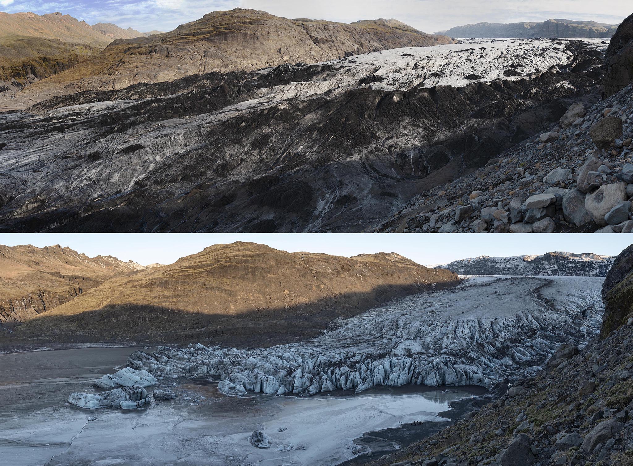
Ljósmyndir frá EIS myndavélastöðum framan Sólheimajökuls 2012 og 2023. Nú hefur verið sett upp myndavélastatíf nr. IS.006. Myndir: James Balog, EIS/Jöklasýn.
